On Pinzarie Hill above Craigencoon is a new forestry plantation. Buried under this is the Mediaeval field system (see maps and photo below). In Mediaeval times this would all have been part of Nether Craigencoon land. The lower part of Pinzarie Hill is quite steep, but above there is some more gently sloping land on the bench, which showed the marks of old fields. Just above the stell was a group of four fields, which I mapped before the trees were planted. I used the basic technique of compass and pacing, a pencil and notebook. Accuracy cannot be guaranteed by this method, but it is good for a general picture.
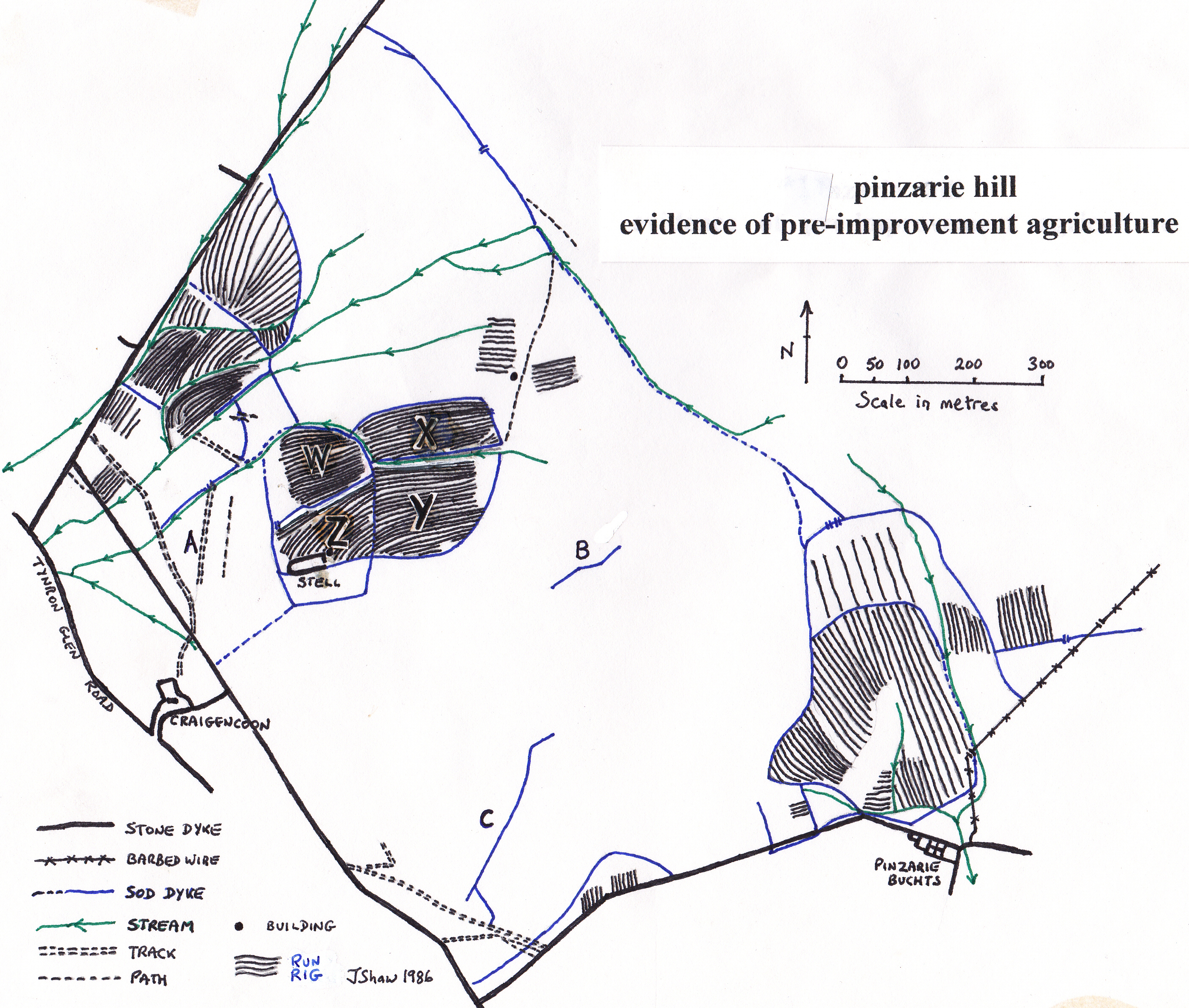
These higher slopes on the outfield must have been a hive of activity. Apart from the four fields, there were other fields now by the Auchenbrack march and which indeed continue along the hillside on Auchenbrack. I also found a few patches of run-rig which did not seem to be enclosed, together with some other small patches which showed the green of cultivation, but did not appear to have rigs. I mapped the fields on the Pinzarie side too, just above High Pinzarie, that are not under immediate threat and so can still be clearly seen. These old fields and sod dykes can be seen on many similar slopes throughout the glen.
The Four Fields
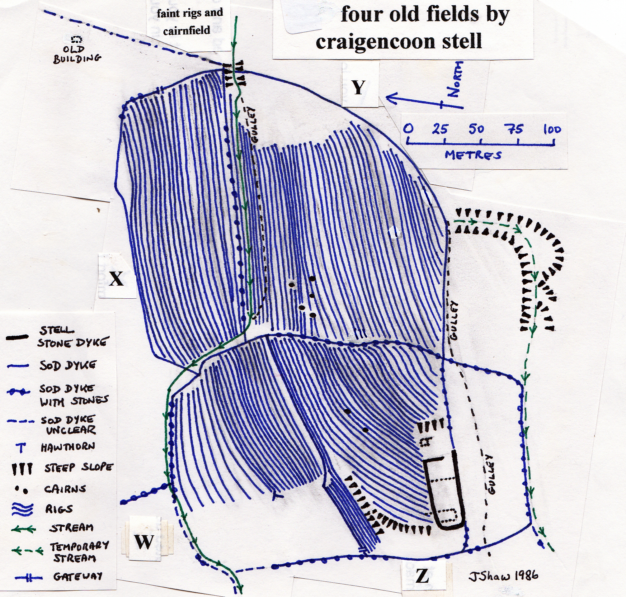
The four fields W,X,Y and Z above the stell have been mapped as well as I could on the map below and the exact number of rigs and their position have been marked. I have failed to show the S-shapes properly, but these show up well on the photo. These run-rig fields sloped fairly gently to the west-south-west and lay on the shoulder of the hill. The earth dyke running down the centre north to south is a huge bank of stones containing a number of large boulders and is still there, having been left as a forestry ride. The photo of these fields was taken from Thistlemark, facing east and up the hill. With the sun at a low angle the old fields showed up beautifully, as did the old loans leading up to these high fields. The forestry road has now cut right through the middle of this area.

FIELD W
This field had 22 rigs in 100 metres, widely-spaced in the north, closely in the south. The lower west side was unsuitable for cultivation, being too wet. The earth dyke in the north-west corner was not clear. A prominent hawthorn stood on the edge of cultivation and stands yet by the forestry road.
FIELD X
Here 19 rigs were in 75 metres. The earth dyke in the north-east corner was still 0.7 metres high and 3.5 metres across. To the north-east was the remains of a small building, beside what was a well-used sheep track, and surrounded by some disturbed ground. There were fainter rigs to the east and west of this building. This was most likely to have been a shepherd’s hut, perhaps used as a shieling.
FIELD Y
This was the largest field with 39 rigs in 135 metres. The field sloped west-south-west, gently at the top, more steeply lower down. This convexity made it impossible to see the bottom of the field from the top. The east corner was marsh. There was a stream plus a gulley marking an old stream in the north part. A group of what I take to be prehistoric field clearance cairns obstructed the rigs. I am sure they predate the rigs as the rigs were clearly stopped by the cairns. Why were these cairns not thrown onto the sod dykes? They must have been a nuisance.
FIELD Z
There were 33 rigs in about 125 metres. This field contained the much more recent stell (sheep pen), now on the bend in the forestry road. Associated with the stell was a possible small building to the east and other features marked by dotted lines on the map. The west, lower end of the field was too steep to plough. The sod dyke on the west side lay at the top of a sudden change in slope and at the bottom end of the flatter ground on which these fields were situated.
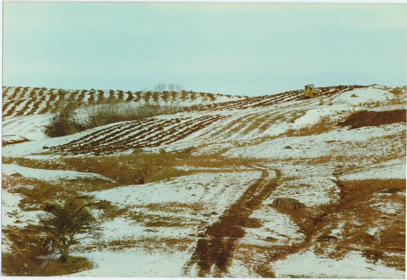
New rigs replace the old on Pinzarie Hill, as the forestry machine ploughs new furrows into the Mediaeval rigs in January 1987
Sod Dykes
The dykes surrounding the fields often contained some large stones, but were largely made of earth. They must have been some metre and a half high, probably helped by the use of stakes driven into the top. They would have been made by piling up surrounding sods plus stones from the fields. There was sometimes quite a ditch alongside. Several hundred years of disuse has led to their degradation. Even so, some were very clear indeed and stood over 50 centimetres high. How they were farmed has already been described, but when is a very interesting question.
When Were The Fields Used?
For people to work these fields, which we do not consider worthwhile nowadays, they must have been desperate for food. Two things could account for this. Firstly, if the population was expanding, for instance in the thirteenth century, when there was a measure of peace, prosperity and a good climate. Secondly, if the land on the valley floor and the infield was producing lower and lower yields. Folk knew little of rotations or field drainage and they could not manure the infield enough.
Then they could become desperate for more land, so they looked up the hill. They cultivated the most promising land, some of which prehistoric farmers had used. When yields reduced on this new land, they moved further up the hill. At times of reducing population, for example after 1350 with the Black Death, or following the many raids, or at times of starvation, the pressure of land was reduced and the new fields may have been abandoned.
The four fields were probably cultivated over a long period, though perhaps discontinuously, as the rigs were ingrained and the sod dykes were substantial. The rigs were curved in the form of an elongated reverse “S”, the relic of Mediaeval ploughteams, which needed a lot of space to turn at the end of a furrow. This S shape partly turned them in the right direction. These rigs are Mediaeval, perhaps twelfth, thirteenth or fourteenth century. It is possible, though, that such fields were still ploughed in the eighteenth century, right up until the Improvements, though they were not shown on the 1772 Queensberry Estate map. The four fields were not marked as rough pasture on the 1850s OS map and they were an oasis of good grass on Pinzarie Hill even in 1985.
These higher plots became superfluous when the stone dykes were built. Pinzarie Hill was enclosed with one long dyke and crop yields vastly improved so that enough food could be grown on the lower land, even for an expanding population.
From the house at Craigencoon the access up the hill was by the tracks or loans marked on the map, the main one being at A on the previous map of pre-improvement agriculture on Pinzarie Hill. The workers, animals, ploughs and sledges used these everyday. Note that one of them goes on to Auchenbrack and one on to Pinzarie as the stone dykes were, of course, not there. There must have been quite a few folk living in the predecessors to the house at Craigencoon, possibly a group of primitive houses.
At the upper limit of cultivation was the head dyke, which was clear enough, though fairly discontinuous, as it ran across the highest part of the hill to join the High Pinzarie head dyke. There is a strange dyke (B) on the top of the hill, which goes nowhere and another one (C) running up the hill, which is equally puzzling, as it too suddenly ends.
The location of these pre-Improvement fields is on the more gently-sloping of the shoulders on glacial till. The farmers avoided the steep slopes of the southern side and chose the embayment facing west. Above the head dyke was land with thinner soils on bedrock and more exposed. Animals were turned out on to this former common land at the top of the hill. Animals must also have wandered on the hill between the cultivated fields and, after cropping, onto the fields to manure them.
These old fields with their remains of sod dykes are a remnant of bygone days, a reminder of a long-lost way of life.
Aird
Each time I walked up to see what birds were on Aird Loch, the old field boundaries and settlements on this stony hilltop between 130 and 180 metres jumped out at me. So much so that I endured the bitter east wind of January 1996 to sketch in the extent of the old field system on the map below.
The modern field boundaries of largely straight and orderly drystone dykes were put in place during the Improvements not long before 1822, or at least, most of them, as a few were added up to 1853 and even two stretches after 1853. Some of these are now lying in ruins. This Improvement field system replaced an earlier layout of small irregular fields, marked on the map in red. Some of the new dykes were obviously built on the lines of the old dykes. The old dykes were robbed to construct the new.
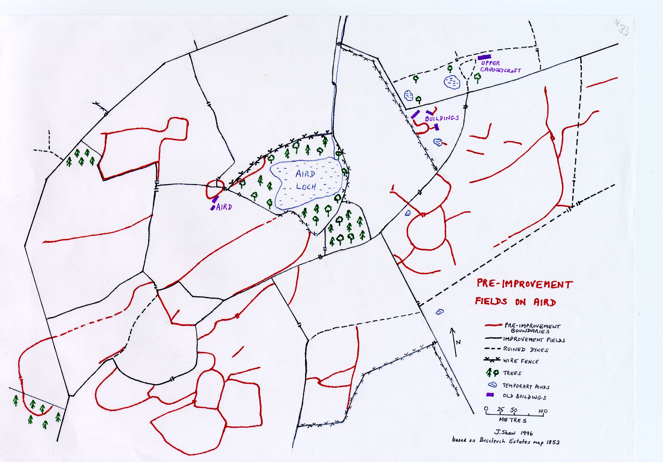
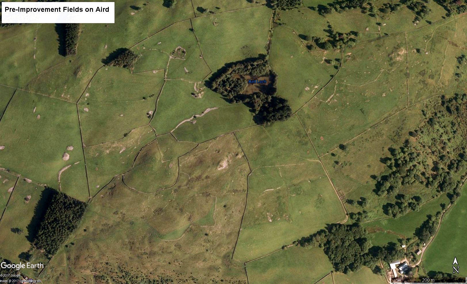
Now there is Google Earth, my rough map can be compared with an aerial photo. They match up pretty well. The newer dykes from the early nineteenth century show up very clearly with their straight lines and larger enclosures. The older dykes are fainter pale lines.
Some of the fields have been ploughed regularly in recent times and old stone dykes have been removed, but other fields are so full of stones and boulders and small rock outcrops that they show no signs of modern ploughing. It is in these fields that the pre-Improvement field system is best preserved.
All the old fields on the map (except the most western on Milton Braes) were on the land of the Barony of Aird and may date from the century or so before the Improvements, ie seventeenth or eighteenth century, an earlier attempt to improve farming practices. These field boundaries are unlike those I described earlier on Pinzarie Hill, which were distinctly sod dykes enclosing very clear old rigs. Some of these old fields could hardly have been ploughed, as they are so full of stones and small rock outcrops, but the pre-Improvement boundaries were at least a good place to put the stones off the fields.
The site of Aird itself is shown on the map. There appears to have been a two-room house plus either some outbuildings or more houses. These houses would have been of unmortared stone with thatched roofs. The site of Aird House has been a jolly good place for dumping more stones in the past two centuries. Somewhere under a pile of stones must be the kiln mentioned in the 1691 Hearth Tax. This whole hilltop contains stone dumps, in piles or in lines, where fields have been cleared, thus making old fields harder to plot.
Apart from Aird, there are also old buildings, now enclosed by a wire fence, on the east side of Aird on the Cairneycroft march. Here were houses, outbuildings, small enclosures and an old pond. I have never seen any reference to these buildings, either on maps or documents. They are very close to the abandoned croft at Upper Cairneycroft, which lies just over the dyke. Could they have been associated with Cairneycroft perhaps?
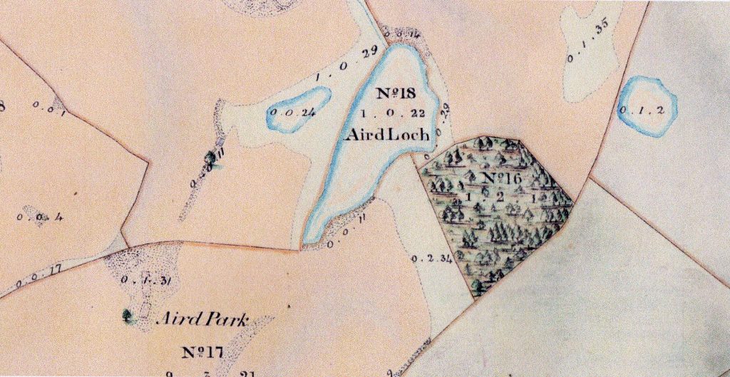
When was Aird abandoned? James Hunter had two hearths and a kiln at Aird in 1691. The Buccleuch map of 1820 marks Aird House in a very large field called Aird Crofts (the infield), of which Aird was quite central and it was probably just inhabited for a few more years. The 1854 Buccleuch map below shows the outline of the house at Aird Park, but apparently under a pile of stones. The stone dykes nearest to Aird House were built after 1820. The old holding of Aird was certainly incorporated into Ford by 1853.
